


11AM Tuesday Update:
Debby gets a little stronger as it continues to meander off of the Georgia and South Carolina coastline.
Winds are now at 60mph with gusts up to 70mph.
5AM Tuesday Update:
No major changes this morning with Tropical Storm Debby as it is meandering off the coast of Georgia and South Carolina.
Debby is moving toward the east near 5 mph. An even slower motion toward the north and north-northwest is expected today, bringing the center of Debby to the South Carolina coast by tonight or early Thursday. A faster motion toward the north and north-northeast across the Carolinas and the U.S. Mid-Atlantic region is expected on Thursday and Friday.
Maximum sustained winds are near 45 mph with higher gusts. Some strengthening is possible today or tonight before the center of Debby reaches the coast of South Carolina. Weakening is forecast to begin on Thursday after the center moves inland. Debby is expected to merge with a frontal boundary over the U.S. Mid-Atlantic on Friday. Tropical-storm-force winds extend outward up to 175 miles from the center. The estimated minimum central pressure is 995 mb.
11PM Tuesday Update:
Debby is quite expansive, producing heavy rain from Jacksonville, FL to Norfolk, VA. Tropical-storm-force winds extend outward up to 205 miles from the center.
Debby is slowly moving eastward off the GA/SC coasts tonight. With the center now interacting with the warm Atlantic waters, some slight strengthening is expected tomorrow. It will stay along the SC coast through Thursday, continuing to bring heavy rainfall from southeast GA to VA.
The Mid-Atlantic and Northeast could receive 3-6" of rainfall Friday into this weekend as it moves northward.
For additional rain, wind and storm surge forecasts, please see the prior update.
5PM Tuesday Update:
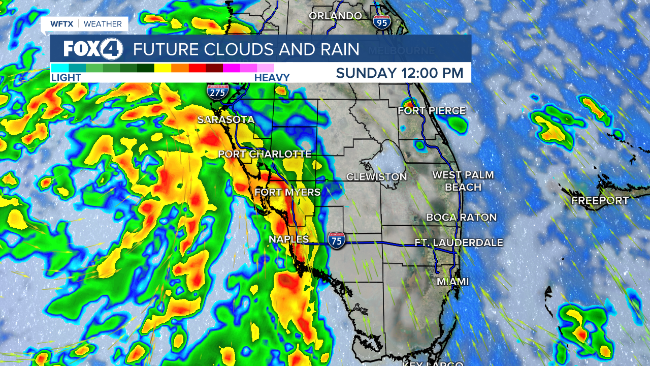
Debby has slowed down to a crawl at just 3mph. Its slow motion will continue to produce torrential rainfall over parts of SC through Thursday. Thursday afternoon, the center of the system is forecast to move into NC, before picking up speed and heading into VA on Friday. It will then move quickly into and through the Northeast this weekend.
SWFL IMPACTS: Wednesday stays breezy with gusts to 25 mph. We'll have scattered showers and storms after 11am but additional heavy rainfall isn't expected. High Surf Advisories remain in effect through 8pm. There's a high threat for Rip Currents through Thursday evening. A Flood Warning remains in effect for Horse Creek in DeSoto county and for the Myakka River at Myakka River State Park in Sarasota county.
WIND: Tropical storm conditions are expected along the Georgia coast for the next few hours. Tropical storm conditions are expected to continue along the coast of South Carolina through Thursday night. Tropical storm conditions are expected within the tropical storm warning area in North Carolina beginning early Wednesday.
STORM SURGE: The combination of storm surge and tide will cause normally dry areas near the coast to be flooded by rising waters moving inland from the shoreline. The water could reach the following heights above ground somewhere in the indicated areas if the peak surge occurs at the time of high tide between 2-4 feet from the South Santee River, SC to Cape Fear, NC.
RAINFALL: Debby is expected to produce potentially historic rainfall totals of 10 to 20 inches, with maximum amounts of 25 inches, bringing areas of catastrophic flooding across portions of the eastern half of South Carolina, and southeast North Carolina through Friday.
From central South Carolina to the Update of South Carolina, northward into Southwest Virginia, portions of the Mid-Atlantic States, western and northern New York State into Northern New England, 3 to 6 inches with local amounts to 8 inches, are expected through Saturday. This rainfall will likely result in areas of considerable flash and urban flooding, with river flooding possible.
5AM Tuesday Update:
Tropical Storm Debby continues to slowly move northeast at 7mph and is currently 50 miles southwest of Savannah, Georgia. This storm will continue to bring heavy rain from Georgia into both North and South Carolina. Debby's center is expected to move offshore of the Georgia coast later today and that could allow for some slow strengthening of the storm.
Maximum sustained winds are near 45 mph with higher gusts. Tropical-storm-force winds extend outward up to 205 miles to the east of the center. A weather station on Folly Beach, South Carolina, recently reported a sustained wind of 41 mph and a gust to 53 mph.
11PM Monday Update:
Debby continues to weaken and only has winds of 45 mph. The storm continues to bring heavy rainfall parts of the Southeastern US. Bands from Debby's tail will continue to swing through Florida tonight into Tuesday.
5PM Monday Update:
This afternoon Debby was downgraded back to a tropical storm. The storm continues to be a eventual rainmaker, and will bring major flooding to the southeastern United States as the storms slows down in the days ahead.

As of 5pm, winds are down to 50 mph with gusts of 65 mph. On the forecast track, the center will move across southeastern Georgia tonight and Tuesday, move offshore of the South Carolina coast by late Tuesday and Wednesday, and approach the South Carolina coast on Thursday.
7AM Monday Update:
Debby has officially made landfall near Steinhatchee, Florida as a category 1 hurricane. The storm will continue to bring life-threatening storm surge in portions of Florida and eventual will bring major flooding to the southeastern United States as the storms slows down in the days ahead.
Air Force Reserve Hurricane Hunter aircraft observations and Doppler radar images from Tallahassee indicate that the center of Hurricane Debby made landfall around 700 AM in the Florida Big Bend. Data from the Hurricane Hunters indicate that the minimum pressure at landfall was around 979 mb and the maximum winds were estimated to be around 80 mph.
11 PM Sunday Update:
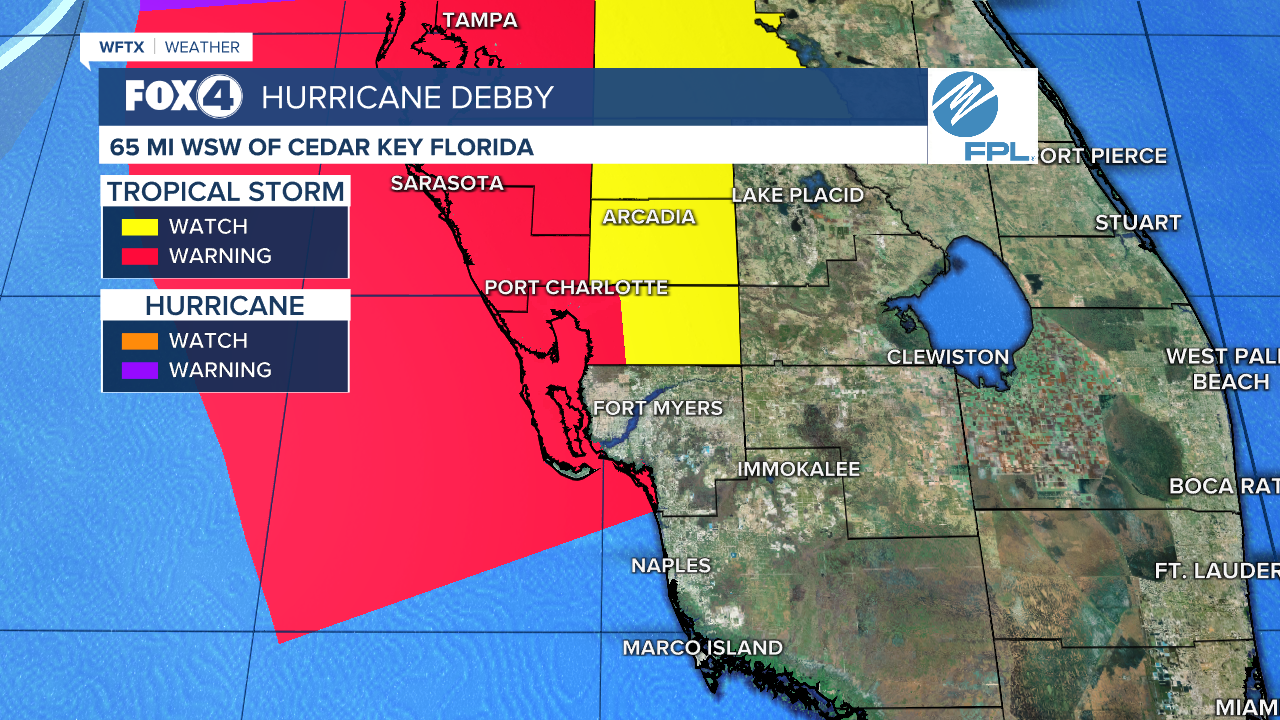
Debby is officially a Category 1 hurricane, 65 miles west of Cedar Key, moving north toward the Big Bend. Landfall is expected around 8am in the Big Bend region of northern FL as an 85 mph Cat. 1 hurricane.
For SWFL, breaks in the rain will allow high waters to recede overnight, but you'll want the rain gear close on Monday. An additional 1-2" of rain will be possible as scattered downpours move through.
A Flood Warning is in effect for coastal Collier county until 8am Monday. A Flood Watch remains in effect for Lee, Charlotte, DeSoto and Sarasota counties through Monday evening.
Tropical Storm Watches and Warnings have been canceled for Lee and Collier counties. Tropical Storm Warnings remain in effect for coastal Lee, western Charlotte and Sarasota counties.
Monday stays breezy with gusts between 30-35 mph, not tapering into the 20s until after 7pm.

8 PM Sunday Update:
The severe threat has ended for SWFL. Tornado watches have expired. The exception is Sarasota county where a Tornado Watch is in effect until 6am Monday.

It will stay breezy overnight into Monday with gusts to 35 mph.
Rain is thinning out, but we'll continue to have scattered downpours overnight and through the day tomorrow, producing another 1-2". This on top of what we received this weekend may create additional flooding. *A Flood Watch remains in effect for Lee, Charlotte, DeSoto and Sarasota counties until Monday evening.*
Here's a look at some of the rainfall totals from Debby this weekend.


Debby is only 4 mph shy of becoming a Cat. 1 hurricane, moving north toward the Big Bend. Landfall is expected after sunrise tomorrow morning as an 85 mph Cat. 1 hurricane. Thereafter, it will move inland, stall, and become a major flooding threat to southern GA and SC next week with 16-20" of rainfall possible from Savannah, GA to Charleston, SC.

5 PM Sunday Update:
Debby remains offshore with the center of circulation about 120 miles due west of Tampa. As the northward progression continues, coastal flooding from storm surge and gusty winds will wind down this evening.
Bands of heavy rainfall will continue overnight with an additional 1-2" of rainfall expected through Monday. This could lead to more flooding. MANY ROADS ARE FLOODED ACROSS SWFL. If you encounter a flooded road, TURN AROUND. There's no way to know how deep the water is, and we've seen multiple vehicles stranded.
Collier county is no longer under a Tropical Storm Warning. We expect other watches and warnings to expire as Debby moves northward.
Debby is moving toward the north near 12 mph. A gradual decrease in forward speed with a turn toward the northeast and east is expected on Monday and Tuesday.
On the forecast track, the center will move across the northeastern Gulf of Mexico through tonight and reach the Florida Big Bend coast around midday Monday as a Category 1 hurricane. Debby is then expected to move slowly across northern Florida and southern Georgia Monday and Tuesday.
2 PM Sunday Update:
The center of Debby is about 100 miles off SWFL's coastline, but with our positioning on the front right side, flooding rainfall, isolated tornadoes and coastal flooding will remain threats through the afternoon, winding down this evening.
Tornado Watch for all of SWFL until 8pm...we will continue to see possibility for quick spin up tornadoes in these outer bands. pic.twitter.com/wm5sUgV2CR
— Katie Walls (@KatieWallsTV) August 4, 2024
Maximum sustained winds are near 65 mph with higher gusts. Rapid strengthening is forecast, and Debby is expected to become a hurricane by tonight before it reaches the Florida Big Bend coast. Weakening is expected on Monday and Tuesday after Debby moves inland, creating a major flooding concern for southern GA and SC with totals ranging from 10-15" and isolated higher totals.
Conditions in SWFL will gradually improve after 6pm from the south to the north. Tornado Watch remains in effect until 8pm.
11 AM Sunday Update:
Bands of heavy rainfall, 30-45 mph wind gusts and isolate tornadoes will remain threats through the afternoon.
Conditions will gradually improve late afternoon into the evening. Until then, stay inside and off the roads unless necessary. We are receiving multiple reports of flooded roadways, especially along the coast, where 2-4 feet of coastal flooding are expected through the afternoon.
Debby is getting stronger this morning and is taking aim at the Big Bend, where landfall is expected tomorrow morning as a Category 1 hurricane.
Even though the center of circulation will stay 100+ miles offshore, with tropical storm force winds extending 140 miles from the center, we'll continue to feel wind gusts between 30-45 mph throughout the afternoon, tapering tonight.
At 1100 AM, Debby was moving toward the north-northwest near 13 mph. A turn toward the north is expected later today, followed by a slower motion toward the northeast on Monday and Tuesday. On the forecast track, the center will move across the eastern Gulf of Mexico through tonight and reach the Florida Big Bend coast Monday morning. Debby is then expected to move slowly across northern Florida and southern Georgia Monday and Tuesday.
Maximum sustained winds have increased to near 65 mph with higher gusts. Rapid strengthening is forecast, and Debby is expected to become a hurricane by tonight before it reaches the Florida Big Bend coast. Weakening is expected on Monday and Tuesday after Debby moves inland.
5 AM Sunday Update:
Conditions will continue to deteriorate as Debby tracks north- northwest at 13 mph. The center is currently about 120 miles southwest of Fort Myers.
Tropical storm force winds extend 140 miles from the storm's center. With additional strengthening expected, even with the center staying 100+ miles offshore, tropical storm force winds (40+ mph) are likely Sunday with the strongest gusts along the coast.
Debby is expected to make landfall in the Big Bend area as a Cat. 1 hurricane Monday morning.
2 AM Sunday Update:
Conditions will continue to deteriorate as Debby tracks northwest at 14 mph. The center is currently 165 miles southwest of Fort Myers.
Tropical storm force winds extend 140 miles from the storm's center. With additional strengthening expected, even with the center staying 100+ miles offshore, tropical storm force winds (40+ mph) are likely Sunday with the strongest gusts along the coast.
Naples Wind Gust Forecast - Winds will consistently gust between 30-40 mph throughout the day with higher gusts possible at the coast. pic.twitter.com/oQw7LsFAKY
— Katie Walls (@KatieWallsTV) August 4, 2024
Debby is expected to make landfall in the Big Bend area as a Cat. 1 hurricane Monday morning.
11 PM Saturday Update:
Tropical Storm Debby is now about 180 southwest of Fort Myers. Maximum sustained winds are near 45 mph with higher gusts to 60 mph.
Weather will deteriorate across SWFL as the system moves northward overnight. While it will stay offshore, we'll feel most of the impacts overnight through Sunday.

On the forecast track, the center will move across the eastern Gulf of Mexico through Sunday night and reach the Florida Big Bend coast Monday morning. The center is then expected to move slowly across northern Florida and southern Georgia Monday and Tuesday.
Data from NOAA and Air Force Reserve Hurricane Hunter aircraft indicate that maximum sustained winds have increased to near 45 mph (75 km/h) with higher gusts. Additional strengthening is forecast, and Debby is expected to become a hurricane by Sunday night, before it reaches the Florida Big Bend coast. Weakening is expected on Monday and Tuesday after Debby moves inland.
9:00 PM Saturday Update:
Hurricane Hunters are currently investigating Tropical Storm Debby, about 200 southwest of Fort Myers. Maximum sustained winds are near 40 mph with higher gusts. Strengthening is expected as Debby moves northward, and the system is likely to be at or near hurricane strength when it reaches the Big Bend region of Florida.
Tropical-storm-force winds extend outward up to 140 miles to the east of the center.
THREATS TO SWFL:
- Storm Surge - Storm surge of 2 to 4 feet expected from Bonita Beach to Charlotte Harbor to just north of Tampa with higher surges in the Big Bend.
- Rain - Flooding rain threat will begin tonight and continue on Sunday with 4-8 inches expected.
- Wind - Tropical storm force winds are possible (40+ mph), increasing tonight and especially Sunday as Debby is at its closest point to our coastline.
- Tornadoes - Isolated tornadoes are possible this evening through Sunday, especially across coastal and west-central Florida.
