WEDNESDAY MORNING UPDATE:
A broad area of low pressure over the central Caribbean Sea continues to produce a large area of showers and thunderstorms. Environmental conditions are conducive for development, and a tropical depression is likely to form within the next couple of days while the system moves slowly westward into the western Caribbean Sea. Afterward, further development is likely while the disturbance meanders over the western Caribbean Sea through the weekend. The system is expected to turn slowly northwestward by early next week. Interests across the western and northwestern Caribbean Sea should monitor the progress of this system. Regardless of development, heavy rains are expected over Jamaica during the next day or so.
* Formation chance through 48 hours...high...90 percent.
* Formation chance through 7 days...high...90 percent.
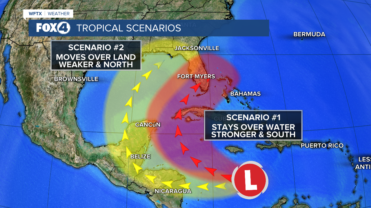
WILL IT IMPACT THE GULF? At this point it is trending that way. The depression or storm is forecast to stay in the western and northwestern Caribbean through the next 6-7 days, next Monday and Tuesday. Thereafter, majority models take it into the Gulf. But, it's far too early to tell where it may track or the impacts it could have.

WHEN WILL WE KNOW MORE? Once the system develops, then models will have a better grasp on where it's tracking and other weather features (an approaching trough of low pressure or ridge of high pressure for example) it will encounter to help steer it.

——————————————————————————————————————————
TUESDAY EVENING UPDATE:
Disorganized showers and thunderstorms over the central Caribbean Sea are associated with a broad area of low pressure. Environmental conditions appear conducive for development, and a tropical depression is likely to form within the next two to three days while the system moves slowly westward into the western Caribbean Sea. Afterward, further development is likely while the disturbance meanders over the western Caribbean Sea through the weekend. The system is forecast begin moving slowly northwestward by early next week. Interests across the western and northwestern Caribbean Sea should monitor the progress of this system.
* Formation chance through 48 hours...medium...60 percent.
* Formation chance through 7 days...high...90 percent.
WILL IT IMPACT THE GULF? It's too early to tell. At this time, the depression or storm is forecast to stay in the western and northwestern Caribbean through the next 6-7 days, next Monday and Tuesday. Thereafter, some models take it into the Gulf. But, it's far too early to tell where it may track or the impacts it could have.
WHEN WILL WE KNOW MORE? Once the system develops, then models will have a better grasp on where it's tracking and other weather features (an approaching trough of low pressure or ridge of high pressure for example) it will encounter to help steer it.
7AM UPDATE: Tuesday November 12th
The National Hurricane Center has once again increased the chance of development for an area in the Western Caribbean.
Formation chance through 48 hours is medium at 40 percent.
Formation chance through 7 days is high at 80 percent.
A tropical wave over the central Caribbean Sea is producing an area of disorganized showers and thunderstorms. Environmental conditions appear conducive for development, and a tropical depression is likely to form by the end of the week as the system moves slowly westward into the western Caribbean Sea. Afterward, the disturbance is expected to meander over the western Caribbean Sea through the weekend and begin moving slowly, generally northwestward, by early next week. Interests across the western Caribbean Sea should monitor the progress of this system.
Long term, computer models are indicating a pull to the north early next week and that could put this system in the Gulf of Mexico and possibly of interests to us here in Southwest Florida. It is a good reminder that hurricane season runs through the end of the month and to keep that hurricane plan ready just in case.
——————————————————————————————————————————
The Atlantic and Gulf of Mexico are quiet but we are monitoring potential development in the Caribbean later this week.

Central and Western Caribbean Sea:
An area of disorganized showers and thunderstorms to the south of Hispaniola over the central Caribbean Sea is associated with a tropical wave. This system is expected to move slowly westward during the next few days, and environmental conditions appear conducive for gradual development.
A tropical depression could form late this week or this weekend while meandering over the western Caribbean Sea.
* Formation chance through 48 hours...low...10 percent.
* Formation chance through 7 days...medium...50 percent.
FOX 4 EVENING METEOROLOGIST KATIE WALLS
If you don't already have our Fox 4 mobile app, you can download it here.


