

CAPE CORAL, Fla. — Was Helene's surge worse than Ian's? That is the case for some communities but not for all. That’s because Ian's path cut northeast through Lee County; whereas, Helene's center remained 180 miles offshore, flooding the entire coastline.
Let's start with Ian. Locations on the front right side of Ian's path saw the worst of the storm surge on September 28, 2022. This is because winds around a hurricane circulate counter-clockwise. This means that winds in the front right quadrant were physically forcing Gulf water onshore and upriver, flooding some communities with more than 13 feet of water.
But, if you were located on the left side of Ian's path in northwestern Lee, Charlotte, and Sarasota counties, then surge was much lower because winds were blowing water away from land.

Here were some of Ian's storm surge heights if you were on the LEFT side of the track
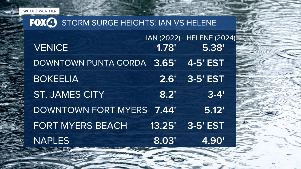
- Venice – 1.78’
- Laishley Park in Punta Gorda – 3.65’ (The record stands with Irma (2017) when the surge reached 4.12’)
- Bokeelia – 2.6’ (nearly 6’ feet lower than the southern part of Pine Island!)
- Boca Grande – 3.1’
Here were some of Ian's storm surge heights if you were on the RIGHT side of the track
- St. James City – 8.2’
- Sanibel – 13.09’
- Fort Myers Beach – 13.25’
- Downtown Fort Myers – 7.44’
- Delnor Wiggins Pass State Park – 10.24’
- Vanderbilt Beach – 11.77’
- Naples – 8.03’
- Marco Island – 7.38’
- Everglades City – 7.33’
HERE ARE SOME COMPARISONS BETWEEN IAN'S SURGE AND THAT OF HELENE
WHY DID THE WORST OF HELENE'S SURGE HIT SO LATE?
Helene's center remained about 180 miles off the SWFL coastline, running nearly parallel to the Florida peninsula as a Cat. 3/4 hurricane. SWFL stayed on the right hand side. Initially winds were out of the southeast, i.e. "offshore", physically blowing water away from the shoreline.
Then, as Helene pulled northward and made landfall in the Big Bend, winds shifted and became southwesterly, forcing water onshore and upriver. That's why the worst of our surge occurred around midnight on the night of September 26th heading into the 27th.
